.png)
Lake Klopein: Why Engineering Is No Longer Enough

A reflection from the VMA™ (Vertical Meaning Architecture) perspective: on a system that has already survived collapse once, and on the second phase that is just beginning.

Fifteen Hundred Years Later
Mount St. Hemma — historically also Junska gora, in German Hemmaberg — is an 842-metre ridge above the Jauntal valley. It was sacred before it even had a name. People lived there as early as the Bronze Age, around 1500 BCE. A Celtic sanctuary. The Roman settlement of Iuenna below it. Later, one of the most important early Christian pilgrimage centres in all of Central Europe. In the Middle Ages, the pilgrimage church of St. Hemma, from which the mountain takes its present name. An unbroken cultic centre, three thousand years old.
What is striking: pilgrims did not climb the summit because of the summit.
They climbed because of water — because of the spring in the cave of St. Rosalia beneath the peak, to which healing powers were attributed.
The mountain was architectural scenery. The magnet was the water beneath it. Already fifteen hundred years ago, the true value of this landscape lay below the surface, not above it.
We will return to this.
Something keeps drawing me back to these parts.
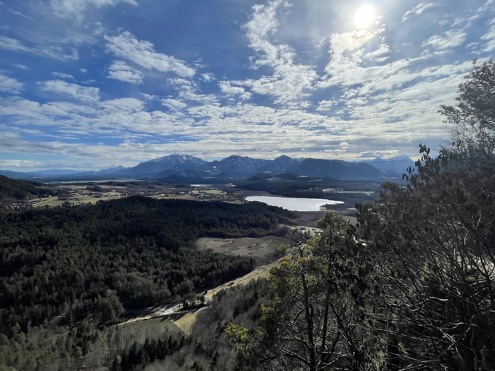
When I stand on Kitzelberg (686 m), where in autumn and winter I encounter only the occasional hiker, Lake Klopein glistens below me — marketed to the public as the warmest Alpine jewel, with temperatures reaching up to 29 degrees Celsius.
The view is spectacular. From here, all of southern Carinthia opens up: Lake Klopein below, the broad valley of Jauntal, with Peca, the Hochobir, and the Košuta ridge in the background. To the north, across the Drava valley, lies the Saualpe massif. Further below, Lake Klein (Kleinsee) and Turnersee to the east.
When I research the possible origin of the name "Klopein," the first thought that comes to mind is the root klop-.
I discover that the lake previously bore the name Lake St. George — after the church and castle on Georgiberg on its southeastern shore.
The village beneath that hill is still called Unterburg today — "below the castle." What does this tell us? The lake was originally named after the castle on the summit. The landscape was defined by height: whoever held the castle on the hill also named the water below. The water was functionally subordinate to the point of control.
Then, in the 13th century, the name migrated downward, to the village of Klopein on the northern shore. According to Heinz-Dieter Pohl, the name Klopein derives from the Slovenian common noun klop — likely in its older meaning of a flat, terraced shoreline (Pohl, 2010; Kranzmayer, 1956–58). In both cases, the water was named after something other than itself: after the saint above it, after the castle, after the shape of the shore.
The lake itself never received its own name.
But I do not see merely blue water.
I see a high-tech ecosystem on life support, telling us something essential: administrative protection exists only on paper. What survives is what is understood and actively managed.
And right now, this ecosystem is facing a decision that will shape the next thirty years. Not because collapse is imminent. But because a window has just opened through which such decisions can actually be financed.
1. The First Phase: Victory Over Collapse (1974–2000)
A glance back at the 1970s reveals that the system nearly failed. The water was becoming turbid, phosphorus was accumulating in the anoxic hypolimnion — the classic scenario of eutrophication, where internal loading takes control of the system (Søndergaard et al., 2003).
The decision that followed was not cosmetic. Under the influence of limnological research and the exceptional work of Hans Sampl, the intervention reached into the mechanism itself:
a ring of sewage collection (interrupting the external nutrient input)
wastewater treatment plants
hypolimnetic withdrawal, following the concept of Władysław Olszewski
This system — known as the Olszewski tube — allows the lake to discharge nutrient-loaded water from its depths, interrupting the internal phosphorus recycling loop (Cooke et al., 2005).
The result:
a reduction of internal loading by tens of percentage points
improved transparency (up to ~8–12 m)
stabilisation of the ecosystem
status as the warmest Alpine lake with drinking-water quality
As the development of Carinthian limnology demonstrates, this success was the result of an integration of science, infrastructure, and policy — not any single solution (Sampl, 2000).
This was the first phase: system stabilisation.
A substantial public investment in a complex system. A remarkably forward-looking and courageous move for its time.
2. The Paradox of Success: From Stabilisation to Saturation
Once the system stabilised, economic prosperity followed.
Lake Klopein today:
offers one of the longest bathing seasons in the Alps
generates a high concentration of tourism
functions as a regional economic engine
And this is where a new problem emerges.
Today the lake is no longer threatened by lack of infrastructure, but by its own success.
Key pressures
Spatial pressure An extreme concentration of people along a limited stretch of shoreline.
Seasonal imbalance Summer peaks against low off-season activity.
New visitor flows via the Koralmbahn With regular service between Graz and Klagenfurt now operating, the region's accessibility has changed dramatically. This is an opportunity. It is also a pressure the current infrastructure was never designed for.
Hidden fragility of the system Climate change is prolonging thermal stratification, which increases the risk of renewed phosphorus release (Jeppesen et al., 2020). In other words: a system we stabilised using 1970s technology now operates under climatic conditions we never engineered for.
3. The Slovenian Context: Podjuna, the Mountain of St. Hemma, and a Shift That Is Actually a Return
Lake Klopein lies in Podjuna (the Jaun Valley), a region whose name derives not from a river but from the ancient settlement of Iuenna beneath the Mountain of St. Hemma.
We return here to the story from the beginning.
Space was once defined by height — by the point of control, by what dominates the landscape. Jaunstein, Hemmaberg, Kathreinkogel, Kitzelberg: whoever controls the summit controls the landscape.
But we now know that pilgrims climbed these summits for the springs.
This means that the shift I am describing — from height to depth, from dominion to understanding, from control to stewardship — is not a shift in the proper sense. It is a return.
A return to the original relationship with this place, which people understood for centuries before we renamed it a "destination."
The Jauntal took its name from the height that dominated the landscape. But what mattered was the water that sprang from beneath — always. The future of this place is not determined by the summit, but by the depth: the state of water we can barely see.
The first phase stabilised the water. It is time for the second phase.
The Austrian Academy of Sciences is leading the research project IUENNA (openIng the soUthErn jauNtal as a micro-regioN for future Archaeology), which treats the Jauntal as a unified cultural system — linking the sites of Hemmaberg, Globasnitz/Globasnica, Jaunstein/Podjuna and St. Stefan as a single micro-region within an open scientific infrastructure (ÖAW, 2024). This represents a holistic view of the territory.
The next move would be to integrate water — Lake Klopein, Turnersee, Pirkdorfer See, and their shared watershed — as part of the same micro-region. Not as a separate tourist entity.
4. What the Region Is Already Doing — and Why That Is Not a Small Thing
Before looking at what could be done, let us look at what the region is already doing.
Sustainability initiative: The Klopeiner See – Südkärnten – Lavanttal region is a project partner in implementing the UN Sustainable Development Goals across six Carinthian tourism regions and three protected areas, with the goal of obtaining the Austrian Ecolabel.
"4 Seen" Postbus Shuttle pilot: alternative mobility for visitors between the lakes in the municipalities of St. Kanzian and Eberndorf.
Kärnten Aktiv Card 2025: an integrated system enabling measurable tracking of visitor flows.
Badehaus St. Kanzian: year-round infrastructure extending the season beyond the summer peak.
These are building blocks, not finished products. The region is actively pursuing sustainable solutions — but the question remains whether these building blocks are connected into a system that could be funded as a coherent whole through EU instruments.
Here lies the opportunity.
5. The Second Phase: An Architecture of Systemic Solutions (2026+)
If the first phase was engineering, the second must be systemic, digital and biological.
Below are some feasible project directions within EU instruments whose funding cycles are opening right now.
I. Digital Twin and Visitor Flow Management
Setting up a Smart Lake system:
real-time monitoring (temperature, O₂, phosphorus load, visitor flows)
public beach-occupancy signalling (green–yellow–red)
redirection of visitor flows to less-burdened points (Turnersee, Kleinsee, Pirkdorfer See)
integration with Aktiv Card data and the Postbus Shuttle system
Key principle: managing capacity without closing off the shoreline.
Relevant EU framework: The currently open Interreg Alpine Space – Capitalisation Projects call (deadline 30 June 2026) focuses on transferring existing solutions in mountain tourism and the circular economy, so it does not directly match lake tourism. The real entry windows for a Smart Lake are upcoming classic calls under Interreg Alpine Space and related programmes — Interreg Central Europe and Interreg Euro-MED — where models from projects such as DESTI-SMART and Smart Tour already demonstrate that this approach works in destinations under tourism pressure.
II. Natural Retention Systems (Nature-Based Solutions)
Instead of more concrete:
rain gardens
reed-bed filter strips
permeable surfaces for new parking areas
revitalisation of tributary streams
These systems reduce nutrient and micropollutant inflow before it reaches the lake (EEA, 2018).
Relevant EU framework: LIFE 2026, sub-programmes Nature & Biodiversity and Circular Economy and Zero Pollution (call opened on 21 April 2026, deadline 22 September 2026, total budget €589 million). This exact type of measure is among the priority topics for the transition to nature-based water protection.
III. Circular Lake Economy
Building a local model:
a "Lake-Friendly" certification for accommodation, gastronomy and farms
linking tourism with agriculture (reducing nitrogen input in the catchment)
financial incentives for shoreline property owners to transition to permeable surfaces and native planting
integration with the Drau-Radweg cycling route and the Karawanken UNESCO Global Geopark (an existing transboundary structure already featuring the Mountain of St. Hemma on its pilgrimage trail)
Relevant EU framework: LIFE – Circular Economy & Quality of Life, and upcoming Interreg Alpine Space windows under the priority Carbon neutral and resource sensitive Alpine region.
IV. Lake Klopein as a European Blueprint
Lake Klopein is one of the few documented cases of successful rehabilitation of a eutrophic Alpine lake through hypolimnetic withdrawal. This is not a local story. It is data that interests researchers of lake ecosystems across Europe, because European lake destinations — Lake Constance, Chiemsee, Lake Bled, the northern Italian lakes — are moving along exactly the same curve: stabilisation → saturation → risk of re-eutrophication under climate change.
Lake Klopein was once first. It could be first again — not as a laboratory, but as a reference case of best practice for the second phase of management: from engineering rehabilitation to systemic resilience.
This is precisely what LIFE Strategic Integrated Projects (SIP) are designed for: multi-year projects that integrate several sectors and become a methodological reference framework for other regions. SIP concept notes are due by 3 September 2026.
6. The Risk of Summer Overload: A Concrete Scenario
I am often asked why I risk predicting crises that are not yet visible. The answer is simple: in complex systems, it is dangerous once they do become visible.
A scenario that can still be avoided:
A summer weekend, 34 °C, the Koralmbahn brings in two full trains from Graz. Car parks full, access roads blocked, bathers packed along the shore in densities that exceed physiological comfort. The water is clean, the services work, but the guest experience is poor. Social media carries the first wave of "overcrowded" reviews. In subsequent seasons, the more affluent segment of guests — also the most profitable — begins to go elsewhere.
This is the classic paradox of success: a destination is most vulnerable at the very moment it appears strongest.
The measures that defuse this scenario are not dramatic:
Real-time occupancy signalling via the existing Aktiv Card infrastructure
Redirection to Turnersee, Kleinsee and Pirkdorfer See via the "4 Seen" Postbus Shuttle the region already runs
Dynamic parking pricing in the style of Alpine ski resorts
A "Lake Explorer Day" package for high-density days — cycling along the Drau-Radweg, lunch at a Lake-Friendly inn, swimming at a less-burdened lake
None of this is invention. All of it exists in comparable regions. The only question is who connects these pieces into a coherent project that can be funded.
7. Why an Advisory Bridge Is Needed
The transition from "cleaning up" to "intelligent management" is not a technical problem. It is a problem of translation:
from science into policy
from data into decisions
from local ideas into funded EU projects
from existing initiatives (UN SDG partnership, Aktiv Card, 4 Seen) into a coherent next-generation system
European frameworks (OECD, 1982; EEA, 2018) are unambiguous: successful solutions are not isolated measures but coordinated systems. And coordination, if we are honest, is the rarest skill in the EU project ecosystem — not funding.
Local institutions know what they need. The EU has the money. Between them stands a gap that someone has to bridge — with fluency in both languages.
Conclusion: What the Pilgrims Already Knew
Lake Klopein has once before shown that it knows how to do things right.
Not because it was ever untouched. But because it was once understood.
Today it stands before a new threshold.
The question is no longer how to clean it up. The question is how to build a system that is resilient to the future.
The window for this second phase opened this very week, on 21 April 2026. It closes in September. Between these two dates, decisions will be made that determine what this landscape will look like thirty years from now.
It is worth pausing on this: fifteen hundred years ago, the pilgrims on the Mountain of St. Hemma knew exactly why they were there. They did not come for the summit. They came for the water that flowed from beneath it.
Somewhere along the way, we forgot.
The second phase invents nothing new. It only returns us to what the people of this landscape understood for centuries: that depth determines height, not the other way around.
History is not being written in this moment through technical solutions. It is being written through an architecture of decisions.
The problem of lakes is not a shortage of solutions. The problem is a shortage of management.
And that is precisely what the next EU cycle funds.
References
Kranzmayer, E. (1956–1958). Ortsnamenbuch von Kärnten, I–II. Kärntner Geschichtsverein, Klagenfurt.
Pohl, H.-D. (2010). Unsere slowenischen Ortsnamen / Naša slovenska krajevna imena. Mohorjeva založba / Hermagoras, Celovec/Klagenfurt.
Pohl, H.-D. (n.d.). Kärntner Online-Ortsnamenbuch – Ortsverzeichnis mit kurzgefasster Etymologie. Available at: members.chello.at/heinz.pohl (entry: Klopein/Klopinj).
Cooke, G. D., Welch, E. B., Peterson, S., & Nichols, S. A. (2005). Restoration and Management of Lakes and Reservoirs (3rd ed.). CRC Press.
Jeppesen, E., Søndergaard, M., & Jensen, J. P. (2020). Lake responses to reduced nutrient loading.
Olszewski, W. (1961). Die künstliche Tiefenwasserableitung als Methode zur Seensanierung.
Sampl, H. (2000). 60 Jahre. Carinthia II, 190/110, 5–6.
Søndergaard, M., Jensen, J. P., & Jeppesen, E. (2003). Role of sediment and internal loading of phosphorus in shallow lakes. Hydrobiologia.
Glaser, F. (1997). Frühchristliche Denkmäler in Kärnten. Carinthia-Verlag, Klagenfurt. ISBN 3-85378-450-X.
Ladstätter, S. (2000). Die materielle Kultur der Spätantike in den Ostalpen. Eine Fallstudie am Beispiel der westlichen Doppelkirchenanlage auf dem Hemmaberg (Mitteilungen der Prähistorischen Kommission 35). Österreichische Akademie der Wissenschaften, Vienna.
Hemmaberg-Juenna Archaeological Pilgrimage Museum Globasnitz. (n.d.). Hemmaberg: Pilgerzentrum der Spätantike. Museum documentation, Globasnitz/Globasnica.
Austrian Academy of Sciences (ÖAW). (2024). IUENNA – openIng the soUthErn jauNtal as a micro-regioN for future Archaeology (Go!Digital 3.0 project). Austrian Archaeological Institute, ACDH-CH, kärnten.museum, BDA.
GeoPark Karawanken. Hemmaberg pilgrimage site and archaeological area (thematic route).
CINEA. (2026). LIFE Calls for proposals 2026 – €589 million for a greener and more competitive Europe. European Climate, Infrastructure and Environment Executive Agency.
European Environment Agency (EEA). (2018). European waters — Assessment of status and pressures.
OECD. (1982). Eutrophication of Waters: Monitoring, Assessment and Control. Paris: OECD.
Interreg Alpine Space Programme. (2026). Call for Capitalisation Projects (deadline 30 June 2026).


